EXECUTIVE SUMMARY
This initial engineering assessment evaluated Puerto Armuelles as an alternative to Puerto Barú for port development on the Pacific coast of Panama near the municipality of David in the Chiriquí region. A preliminary analysis of bathymetry, oceanographic conditions, site accessibility, and potential environmental impact suggest that Puerto Armuelles likely meets the operational requirements outlined in the Puerto Barú Environmental Impact Statement (EIS), with several advantages, including deep water access, cargo route access to the Pan-American Highway, and unconstrained growth potential away from sensitive ecological habitats and protected areas.
Puerto Armuelles is a natural deep-water port, with nearshore water depths exceeding the required -12m MLWS. The deep-water access that Puerto Armuelles provides would significantly reduce or even eliminate the need for costly capital and maintenance dredging, as required for development of Puerto Barú. This was likely a key factor in the selection of Puerto Charco Azul, the Pacific terminal site for the Trans-Panama Pipeline approximately 10 km south of Armuelles, which can accommodate supertankers. In contrast, access to Puerto Barú would require extensive dredging of the navigational channel, leading to higher costs and increased environmental risks, including sediment dispersion and potential habitat disruption of the nearby David mangroves. Even following dredging, Puerto Barú would remain constrained to large cargo vessels given the narrow estuary channel and the protected status of mangroves in Panama. Avoiding the environmental impacts associated with dredging would not only align with the Puerto Barú developer’s stated sustainable development goals but also provide greater flexibility for future port expansion, including the ability to accommodate larger vessels beyond those specified in the Puerto Barú EIS.
Although Puerto Barú is geographically closer to David, Puerto Armuelles offers two viable access routes to the Pan-American Highway for cargo transportation. Existing access to the highway is currently possible by way of the 37.1 km divided four-lane road, which goes from Puerto Armuelles to Paso Canoas. This preliminary assessment also identified an alternative 30.7 km route that could be developed to avoid most residential areas and minimize local impacts. Despite the longer distance, a review of Puerto Armuelles' existing infrastructure shows that nearby roads offer a scalable and cost-effective cargo route that also would provide access to the materials and equipment need for the port construction. Additionally, the assessment conducted here identified a suitable port site on the south side of the city of Puerto Armuelles. Importantly, this site is just one of several viable locations; formal land and bathymetric surveys are needed to confirm the preliminary findings presented herein.
While Puerto Barú benefits from the shelter provided by the David mangroves, Puerto Armuelles’ location on the west side of Charco Azul is naturally protected by the Burica Peninsula. Our review of more than fifty years of ERA5 reanalysis data shows the prevailing wind and swell wave directions for the region are from the west and south-southwest, respectively. The protection of the Burica Peninsula from the prevailing winds and waves may significantly reduce or eliminate the need for costly breakwater construction. This natural protection has contributed to the operational viability of the Trans-Panama Pipeline’s Pacific terminal to the south of Puerto Armuelles, without the need for wave protection structures.
In conclusion, this preliminary initial screening indicates that Puerto Armuelles has suitable site conditions to support the development of a multipurpose port, with lower environmental risks and greater expansion capacity as compared to Puerto Barú. Its history supporting large-scale industrial operations, such as the port for the Trans-Panama Pipeline, and access to undeveloped waterfront land, existing roads, and nearshore deep water reinforce its suitability as a sustainable and strategic alternative to Puerto Barú for port development in the Chiriquí region of Panama.
1.0 INTRODUCTION
Lynker Corporation (Lynker) has engaged the engineering services of Envis Perú S.A.C. (Envis) to codevelop this document: “Scoping Level Assessment of the Puerto Armuelles Alternative.”
This report outlines the initial phase of an investigation aimed at assessing the feasibility of establishing a new port site at Puerto Armuelles on the western Pacific Coast of Panama as an alternative to the proposed Puerto Barú port site near David, Panama. Puerto Armuelles is located the Chiriquí region of southwestern Panama approximately 80 km to the west of David and the proposed Puerto Barú site (Figure 1-1,). This study focuses on key aspects of road networks and site infrastructure between the city of David, Panama and the proposed alternative port location, and addresses critical factors such as site accessibility, logistical requirements, environmental considerations, and community engagement.
The core tasks during this phase include:
- Identifying a preliminary port site,
- Evaluating road access and conditions,
- Determining the suitability of the proposed site for port facilities
- Reviewing available construction materials and equipment, and addressing preliminary considerations regarding port siting and potential environmental impacts.
If the project is to proceed to subsequent stages of assessment, community consultations and interactions with government agencies will be a necessary step; these discussions were not included in the scope of this report. Instead, this high-level review is intended to provide a well-informed foundation for more detailed evaluations, ensuring that the proposed site aligns with operational, logistical, and environmental objectives. Future detailed studies would build on these findings to support subsequent development decisions.
The main reference for this study has been the use of the existing EIA for the Puerto Barú site, 12km from David in the Chiriquí Province in Panama (Figure 1-1).
Figure 1-1: Study area and regional site location
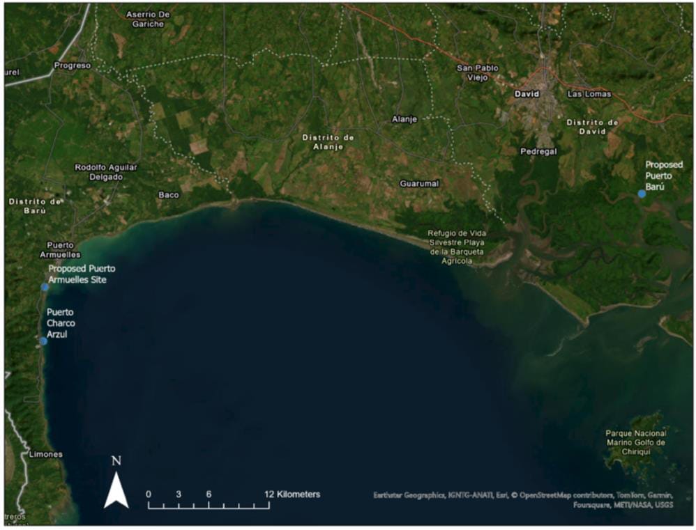
Source: Own elaboration
2.0 ACCESS TO SITE
Access between Puerto Armuelles and the town of David is available through two routes, both connecting to the Pan-American Highway (Carretera Panamericana/Route 1/CA-1) and David. The first route utilizes the existing northbound road out of Puerto Armuelles, traveling approximately 37.1 km to Paso Canoas at the Panama-Coast Rica international border (blue line, Figure 2-1). A review of satellite imagery shows that this route is a divided four-lane road, with two lanes south and two lanes north. This preliminary assessment indicates that the current road should be a suitable cargo access route to Puerto Armuelles, though the distance to David along the Pan-American Highway is further.
An alternative 30.7 km route (red line, Figure 2-1) has also been identified for potential new road construction. This route would bypass major intersections in nearby towns and could be designed to accommodate the dimensional requirements for Stage 02 of the project while also providing more direct access to the Pan-American Highway. However, developing this new road would require significant investment and could introduce environmental impacts compared to utilizing the existing infrastructure. This preliminary assessment indicates that both options could support increased cargo traffic from operations of a port at Puerto Armuelles.
Figure 2-1: Alternative Routes Puerto Armuelles – Pan-American Highway
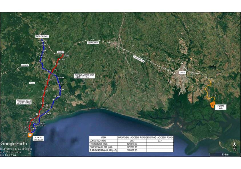
Source: Own elaboration
3.0 PORT SITE, AREA REQUIRED FOR THE PORT FACILITIES
The design and location of port facilities are key aspects to ensure operational efficiency and meet the logistical objectives of a port. In this context, the preliminary analysis of the proposed site aims to identify fundamental requirements related to dimensions, infrastructure, and safety conditions necessary for effective operations.
This section focuses on evaluating the essential criteria to determine whether the site meets the initial operational requirements and to define the priority areas that should be addressed in more detailed future studies. The preliminary assessment will also serve as a foundation to ensure that the port aligns with international standards in terms of capacity, sustainability, and safety.
Through this review, the goal is to establish a clear framework that identifies both the strengths and areas for improvement of the site, supporting strategic planning and decisions related to port infrastructure investment and development.
3.1 General Considerations
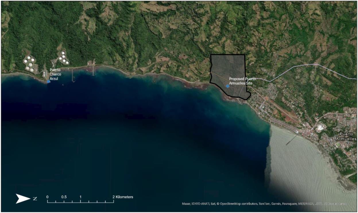
Selecting an appropriate location for the port is crucial, as it directly influences operational efficiency, construction costs, and environmental impact. A preliminary assessment of the region identified multiple viable site locations to the south of Puerto Armuelles, each meeting or exceeding the proposed specifications for Puerto Baru (125 hectares and 540 meters of shoreline access). These preliminary sites were chosen for their favorable bathymetric and oceanographic conditions, as well as their proximity to northbound cargo transportation routes and minimal disruption to existing residential areas. This report presents one of these sites for discussion here, with the expectation that formal land and bathymetric surveys are needed for final site selection.
The proposed area for the port is shown in Figure 3-1. This site is located between the Rio Guanábano outlet and the southern boundary of Puerto Armuelles, providing approximately 1,240 meters of shoreline access in a land parcel that extends across Avenida de Las Arenas to the west, where growth potential is unconstrained. The bathymetric analysis presented in Section 4.1 identified water depths greater than -12 meters mean low water springs (MLWS), ensuring that the area can accommodate large-draft vessels without the need for extensive dredging. This optimizes both operational and initial capital costs. The proposed land access (Figure 3-1, red line) is designed to efficiently connect the port with the region’s main logistical routes, largely bypassing the town of Puerto Armuelles.
Figure 3-1: Proposed Location of Puerto Armuelles – Bathymetric Report

Source: Own elaboration
Section 4.1 below provides a preliminary analysis of oceanographic characteristics, including bathymetry, water level variability, wind roses and ocean currents. If further analysis of the Puerto Armuelles alternative is undertaken, we recommend that a more complete survey and analysis of environmental and hydrodynamic conditions, including wave and hydrodynamic simulations, are completed to guarantee the port's operational safety. In addition to model studies, it is also advised that continuous monitoring systems are implemented to assess initial bathymetric and environmental conditions. However, based on the preliminary analyses using publicly available data, as well as the location of the Pacific terminal of the Trans-Panama Canal approximately 8km to the south of Puerto Armuelles, strongly suggests project viability (Figure 3-2).
While further study is necessary to determine whether a breakwater or traditional pier-style port would be most appropriate, existing nearby infrastructure provides some insights. Satellite imagery from 2023 of the Trans-Panama Pipeline's Pacific Terminal (Figure 3-2, left side) shows a pier-style port without any breakwater structures. Notably, a vessel approximately 350 meters in length is docked at this terminal— significantly larger than the 192-meter vessels proposed for Puerto Barú. This suggests that the naturally sheltered conditions on the southern side of Puerto Armuelles may be sufficient to support large-scale port operations without the need for extensive wave protection infrastructure.
Figure 3-2: Pacific Terminal of the Trans-Panama Pipeline (left) relative to Puerto Armuelles (right).
3.2 Port Operational Infrastructure
Pier Length
In this preliminary assessment, the projected design of Puerto Barú is used as a reference to establish a comparative baseline applicable to Puerto Armuelles. Based on the baseline case characteristics, the main pier is projected to have a length of 512 meters, a width of 35 meters, and an adequate capacity to handle vessels with a total length (LOA) of 192.0 meters, a beam of 30.0 meters, and a maximum draft of 11.0 meters under controlled depth conditions, benefiting from tidal effects.
These dimensions, designed to ensure efficient and safe operations, are equally applicable to Puerto Armuelles in an initial evaluation, considering that operational requirements for this type of port facility tend to be similar in projects with equivalent characteristics. However, additional studies would be necessary to confirm technical feasibility, considering the specific site conditions, dredging requirements, and particularities of the proposed location.
For reference purposes, a conceptual rendering from the EIS is provided in Figure 3-3, with additional plan available in the Section 8.1 of the Appendix.
Figure 3-3: Conceptual Plan of the Multimodal Port of Barú
Source: EIA Puerto Barú
Storage and Cargo Handling Areas
In this preliminary phase, it is estimated that the storage and cargo handling areas required for Puerto Armuelles would be similar to those projected for Puerto Barú, adjusted according to the specific needs of the site. The initial design of Puerto Barú includes a surface area of 15.2 hectares dedicated to primary commercial activities, including the reception and handling of various types of goods, as conceptually illustrated in Figure 8-1 (Appendix).
The products expected to be handled in this area include:
- Dry and refrigerated containers
- Equipment for general cargo handling
- Grains and fertilizers
- Construction materials
- Vehicles and automobiles
- Liquids such as palm oil and fuels (automotive, marine, and aviation)
- Potable water
The port’s functionality also includes specialized infrastructure, such as:
- Silos for grain and fertilizer storage
- Side ramps for bulk materials
- Mobile Harbor Cranes (MHC) with a capacity of over 100,000 annual moves
- Electrified Rubber-Tired Gantry (ERTG) cranes for container yard operations
These features would be adopted as a reference for Puerto Armuelles, with adjustments made according to the specific site conditions and projected logistical demand. Additionally, the storage areas would be designed efficiently to maximize operational capacity and facilitate the flow of goods, ensuring compliance with international handling and storage standards.
Support Facilities
To ensure the operability and efficiency of Puerto Armuelles, support facilities would play a key role in logistics and daily operations. Based on the preliminary specifications of Puerto Barú, the following facilities and services are expected to be adapted to the new proposed location, covering an approximate area of 125 hectares:
- Administrative and Operational Offices: Spaces designed to accommodate administrative offices, operational control areas, and meeting rooms, with an efficient layout to facilitate coordination among various work teams.
- General Warehouses: Infrastructure intended for the storage of essential materials, equipment, and supplies for port operations.
- Basic Services: The provision of potable water, electricity, telecommunications, and sewage systems would be ensured by local service providers, guaranteeing operational continuity and compliance with environmental regulations.
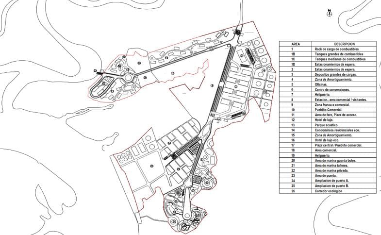
A conceptual site plan of the proposed facilities for Puerto Armuelles is presented in Figure 8-2 (Appendix), which includes the areas described above, as well as other structures necessary to ensure the proper development of its operations.
Port Security
Port security is a critical factor to ensure the integrity of operations, personnel, facilities, and cargo. Based on international port security best practices and considering the preliminary needs of Puerto Armuelles, the following measures and approaches are proposed:
a. Port Operations Security
- Access Control: Implement electronic identification systems, surveillance at access points, and vehicle/personnel registration to prevent unauthorized entries.
- Area Zoning: Classify port areas according to their function (operational, administrative, storage) and establish specific protocols for each zone.
- Activity Monitoring: Use surveillance cameras and trained supervisors to monitor loading and unloading operations and identify risks in real time.
b. Construction Phase Security
- Risk Management Plans: Develop plans to identify specific hazards during the construction phase, such as handling heavy equipment and dredging activities.
- Personal Protective Equipment (PPE): Enforce the mandatory use of appropriate PPE, including helmets, reflective vests, gloves, and steel-toe boots for workers.
- Ongoing Training: Provide continuous safety training to personnel on emergency procedures and safety protocols to reduce construction-related incidents.
c. Infrastructure and Facility Protection
- Perimeter Security: Establish physical fencing around port facilities and implement intrusion detection systems.
- Fire Protection Systems: Design and install hydrant networks, sprinkler systems, and strategically placed fire extinguishers to address fire-related emergencies.
- Power Redundancy: Ensure a reliable power supply to critical systems, such as lighting, surveillance systems, and alarms, through backup generators.
These measures would ensure that port operations at Puerto Armuelles are conducted safely, protecting both people and goods, while complying with the industry's required security standards.
Lighting and Power Supply
A reliable power supply and efficient lighting are essential to ensure continuous and safe operations at Puerto Armuelles during both the construction and operational phases. Following the projected design of Puerto Barú, a similar approach is proposed for infrastructure and energy consumption, adjusted to the context of the new location.
a. Power Supply
- Electrical Infrastructure: The installation of power lines parallel to the main access road is considered to enable an efficient connection to existing networks.
- Renewable Energy Sources: In line with sustainability trends, a "Plan Gran Cliente" would be implemented in collaboration with renewable energy producers such as ENEL Green Power. This plan would prioritize the use of hydropower and photovoltaic sources to cover a significant portion of the port’s energy needs.
- Provider and Distribution: As in the baseline case, the power supply would be provided by a regional distribution company. In the original project, EDECHI (Naturgy) is responsible for electrical distribution and the necessary infrastructure. For Puerto Armuelles, it is projected that a provider with similar capabilities would ensure energy supply to all operational areas of the port.
b. Port Lighting
- Piers and Loading Zones: High-efficiency LED lighting towers would be installed to ensure adequate visibility during nighttime operations.
- Storage Areas and Yards: Uniform lighting using strategically distributed LED lamps to avoid shadows in critical spots.
Based on the Puerto Barú project, it is estimated that the electrical capacity required for Puerto Armuelles would be similar, at approximately 34 kV.
4.0 SITE SUITABILITY FOR PORT
4.1 Oceanographic Conditions
This section summarizes our analysis of the oceanographic conditions—including bathymetry, water levels, wind speed and direction, wave heights, and ocean currents—for Puerto Armuelles and the Chiriquí region.
Bathymetry
Bathymetric data for the Puerto Armuelles area were downloaded from the General Bathymetric Chart of the Ocean (GEBCO) portal (GEBCO, 2024). The GEBCO_2024 Grid offers global elevation coverage in meters on a 15 arc-second (approximately 500m spatial resolution) interval geographic grid, comprising 43,200 rows by 86,400 columns for a total of more than 3.7 billion data points. The vertical datum for the GEBCO elevation data is Mean Sea Level (MSL).
For this analysis, sea bed elevation data were converted to Mean Low Water Springs (MLWS; Section 0 of the Appendix) to better identify the target depths of -11 and -12m MLWS, as specified in the Puerto Barú Environmental Impact Statement (EIS, 2023). Compared to Puerto Barú, Figure 4-1 shows that Puerto Armuelles has easy access to sufficiently deep water near and south of town. Puerto Armuelles' access to deep waters would likely eliminate the need for costly capital and maintenance dredging, significantly reducing both project costs and the environmental impacts associated with sediment dispersion. Additionally, analysis of water level data (Figure 8-4) shows that the tidal range at Puerto Armuelles is only about 3 meters—approximately one meter less than the range reported for Puerto Barú in the EIS. This smaller tidal variation is expected to enhance port operations by minimizing the challenges associated with larger tidal fluctuations, further supporting Puerto Armuelles as a more efficient and sustainable location for port development.
Figure 4-1: GEBCO Bathymetry of the Puerto Armuelles Area Showing Bed Elevations in m MLWS. Elevations Below –12m MLWS are Shown in Light Blue, between –11 and –12m MLWS are Displayed in Dark Blue, While Elevations Above –11m MLWS are Shown in Light Turquoise.
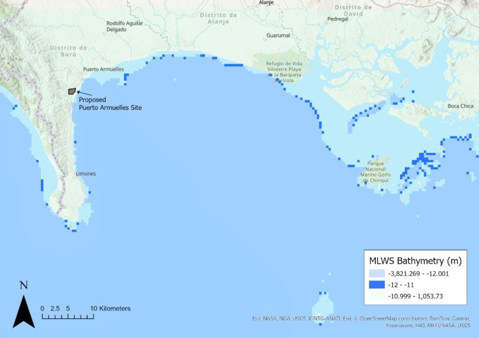
Source: Own elaboration
ERA5 Wind and Wave Analysis
Los datos horarios de viento a una elevación de 10 m y del oleaje del reanálisis ERA5 del Centro Europeo de Predicción Meteorológica a Plazo Medio (ECMWF), que abarcan el periodo comprendido entre 1970 y 2024, se descargaron del Archivo de Datos Climáticos (CDS) del Programa Copérnico de la Unión Europea. ERA5 es el reanálisis de quinta generación del ECMWF, que proporciona datos climáticos y meteorológicos globales completos que abarcan las últimas ocho décadas. Los datos están disponibles a partir de 1940; más información puede obtenerse en: https://cds.climate.copernicus.eu/datasets/reanalysis-era5-single-levels https://cds.climate.copernicus.eu/datasets/reanalysis-era5-single-levels
The ERA5 reanalysis integrates model outputs with global observations into a consistent dataset using data assimilation techniques. This process, like those used in numerical weather prediction, combines prior forecasts with newly available observations every 12 hours to produce the most accurate representation of atmospheric conditions, known as analysis. This updated analysis forms the basis for improved forecasts. For historical periods, the same method is applied at a lower resolution to create long-term datasets.
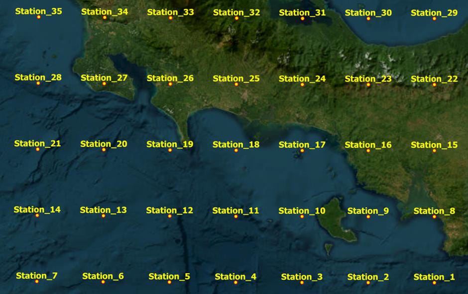
ERA5 provides hourly estimates of various atmospheric, ocean-wave, and land-surface variables. Atmospheric data (e.g., wind) are re-gridded to a 0.25-degree latitude-longitude grid, while ocean wave data are re-gridded to a 0.5-degree grid. Figure 4-2 shows the ERA5 wave grid near Puerto Armuelles, with virtual station numbers (representing model grid centroids) assigned arbitrarily. The exact coordinates for these stations are provided in Table 4-1.
Due to the coarse resolution of ECMWF simulations, nearshore bathymetry is not well-resolved. To minimize the effects of wave refraction, shoaling, and diffraction, we focus our analysis of the 55-year period (1970 to 2024) on deep-water grid points, specifically stations 11, 12, 18, and 19. Results from these stations are presented and discussed in the following sections.
Figure 4-2: ERA5 Hindcast Stations for Wind and Wave Parameters Offshore of Puerto Armuelles. Station Numbering is Arbitrary.
Source: Own elaboration
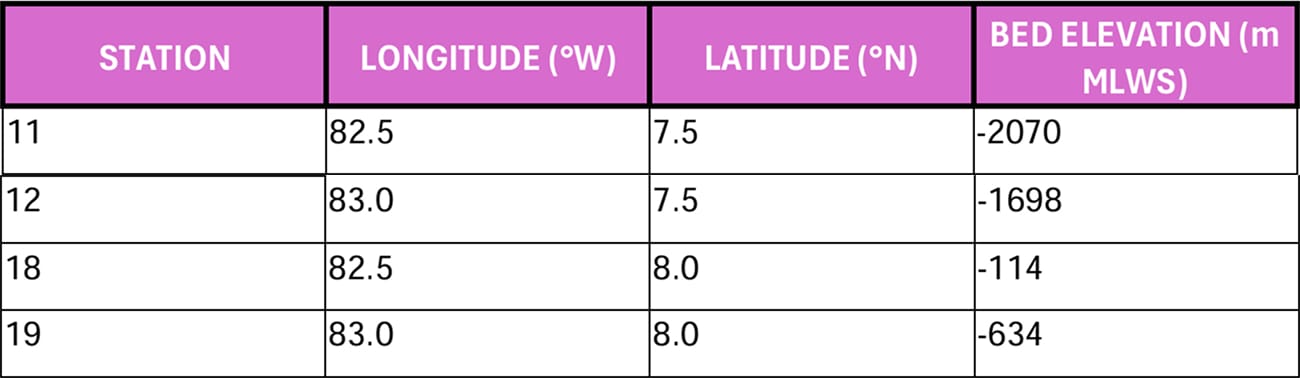
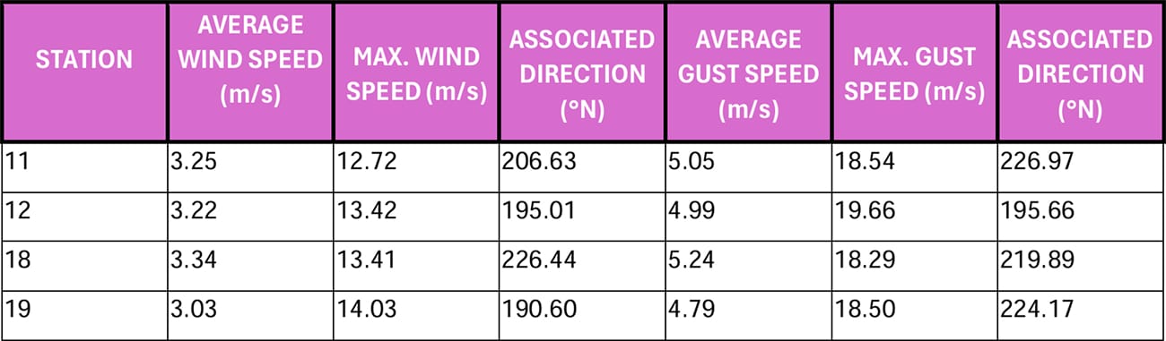
Table 4-1: Location of ERA5 Hindcast Stations Used in the Analysis of Wind and Wave Parameters.
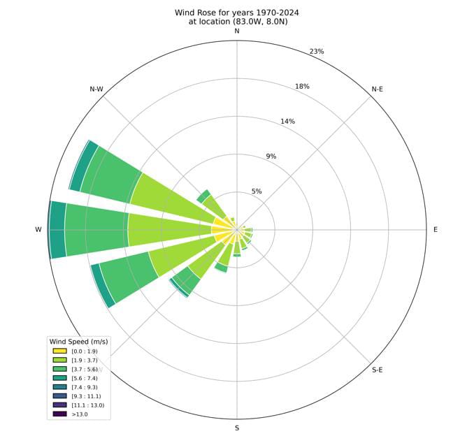
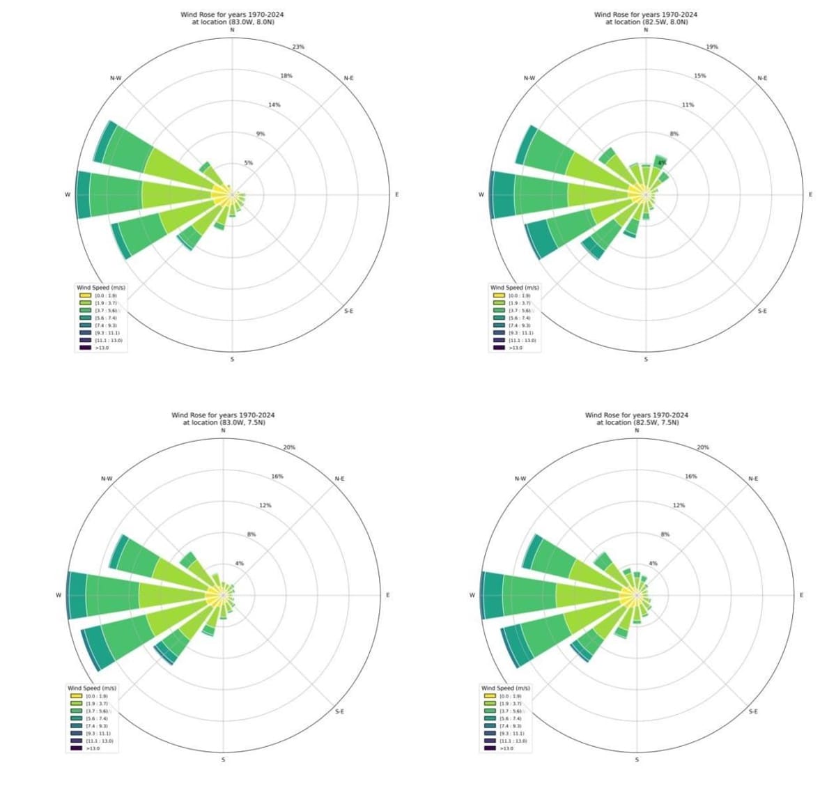
Wind roses are graphical tools that display the frequency and intensity of wind directions over a specific period, providing a clear visualization of prevailing wind patterns and their variability at a given location. Figure 4-3 shows the direction and frequency of 55 years of hourly ERA5 wind data at 10m above the surface for Station 19, an exposed site off the southwestern corner of Burica Peninsula.
The predominance of westerly winds near Puerto Armuelles suggests favorable conditions for port operations, with summary statistics provided in Table 4-2. The natural shelter offered by the Burica Peninsula likely reduces the need for extensive breakwater infrastructure and minimizes operational disruptions caused by wind-driven wave activity. This combination of factors reinforces Puerto Armuelles' suitability as a stable and efficient site for port development. Furthermore, these ERA5 reanalysis findings align with local wind observations recorded at Puerto Armuelles Airport (see details here: https://metar-taf.com/stats/PA-0064#wind).
Figure 4-3: Wind Rose of ERA5 Wind Speed (m/s) at 10m Elevation for the Period 1970-2024, Station 19.
Source: Own elaboration
Table 4-2: Statistics of ERA5 Hindcast Wind Data at the Four Selected Stations.
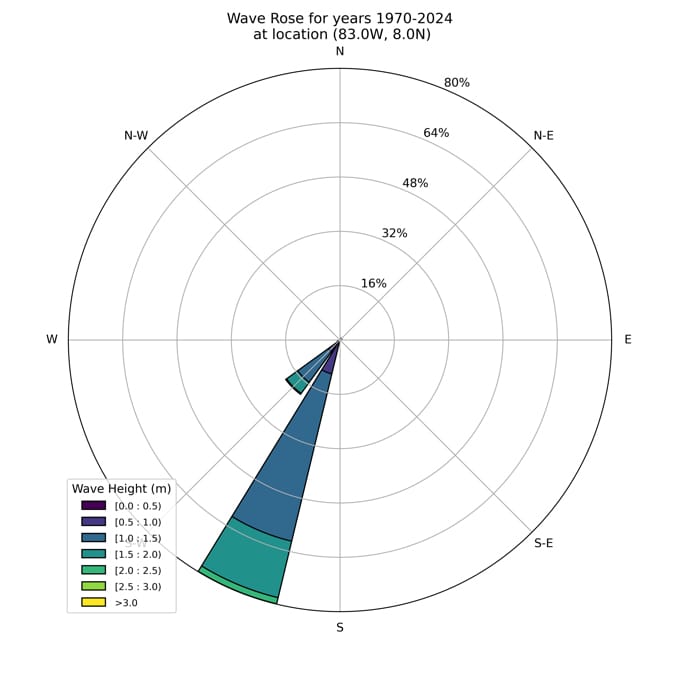
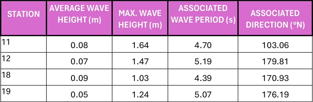
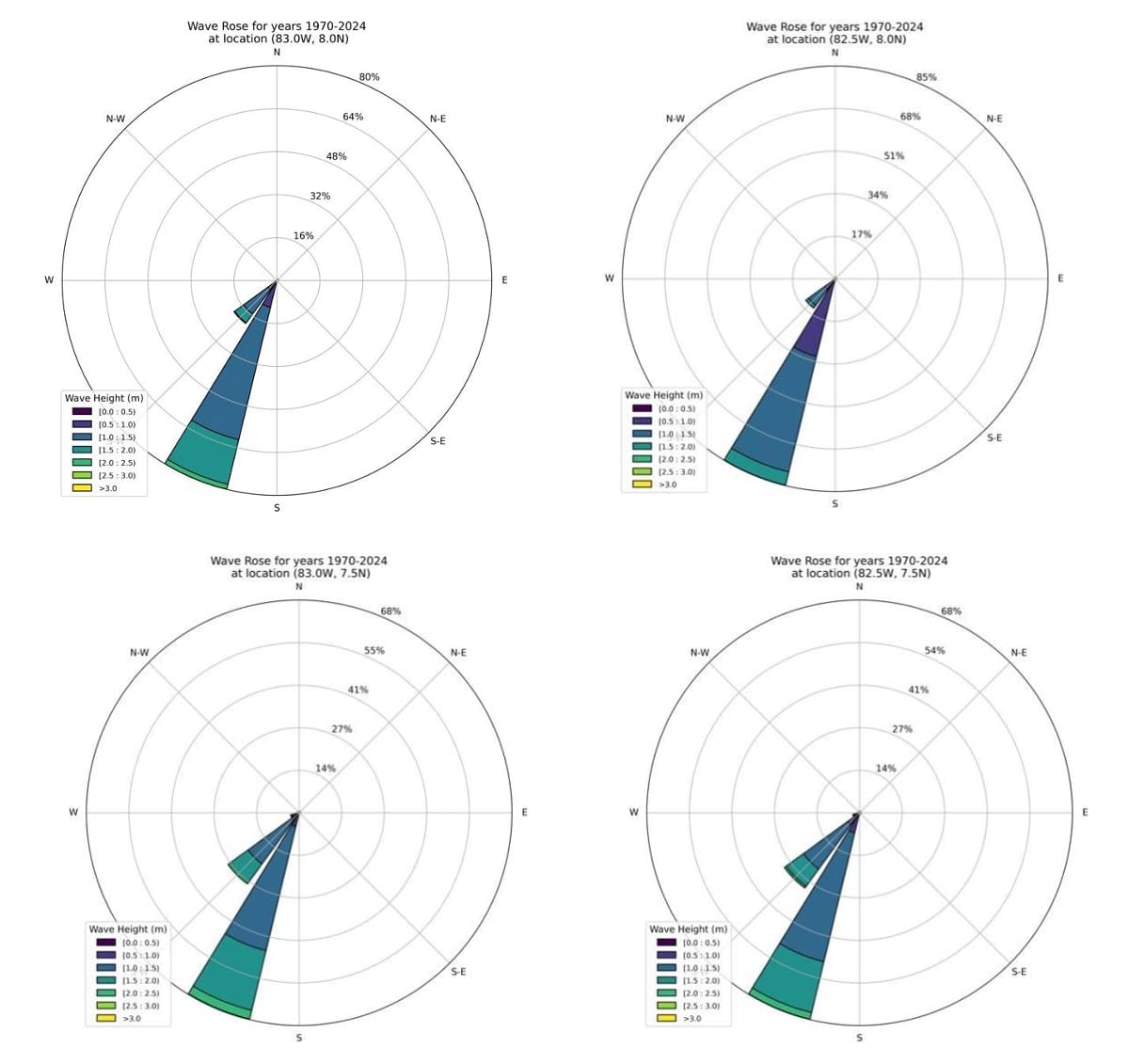
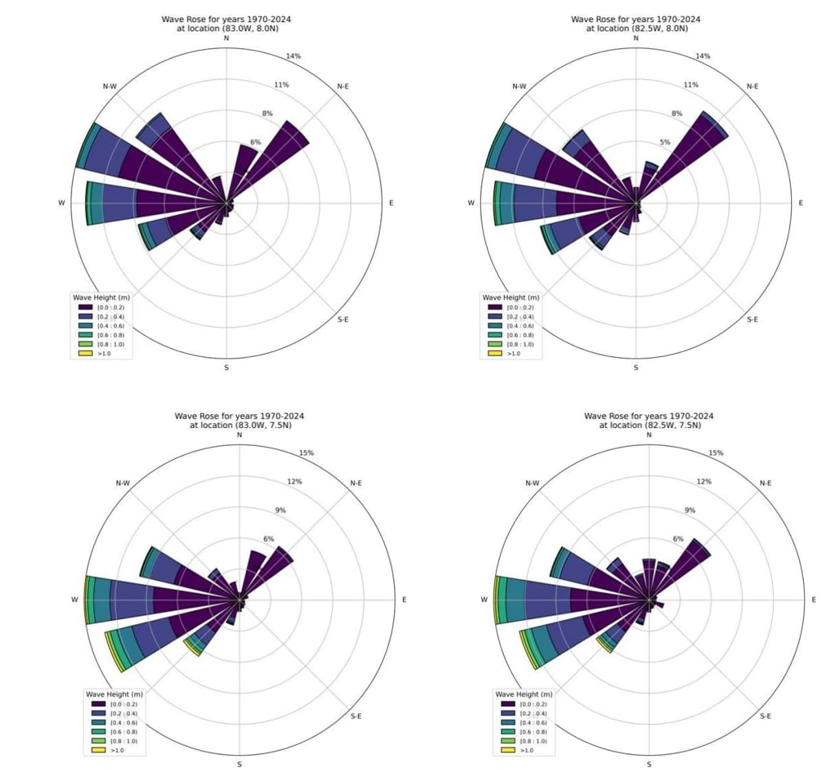
In addition to wind patterns, understanding the influence of swell and wind-generated waves on Puerto Armuelles is critical for assessing port suitability. Using ERA5 hindcast data from the 1970–2024 period, we evaluated total wave energy, swell (long-period waves generated in deep water), and seas (locally generated wind waves). As shown in Figure 4-4, offshore wave conditions at Puerto Armuelles are predominantly influenced by swell from the south-southwest (SSW) and southwest (SW) directions. This pattern indicates that the Burica Peninsula naturally shelters the port area from the prevailing Pacific Ocean waves. Additional wave rose diagrams for all stations are provided in Section 8.5 of the Appendix.
Some westerly swell may diffract around the tip of the Burica Peninsula and refract into the Golfo de Chiriquí, potentially reaching Puerto Armuelles. However, accurately characterizing these wave transformations would require a detailed numerical model of wave propagation and transformation, which is beyond the scope of this preliminary assessment. The absence of protective structures at Charco Azul (Figure 3-2) suggests that wave refraction around Burica Peninsula is minimal.
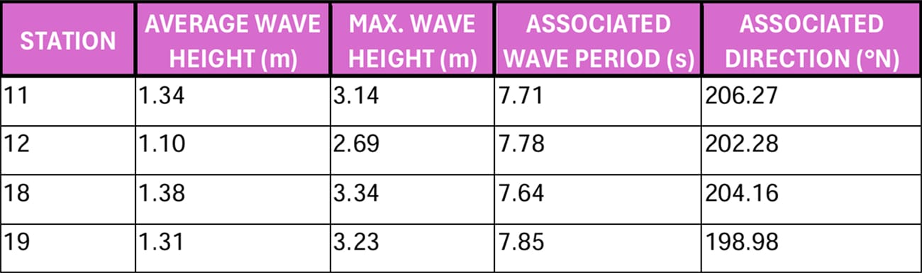
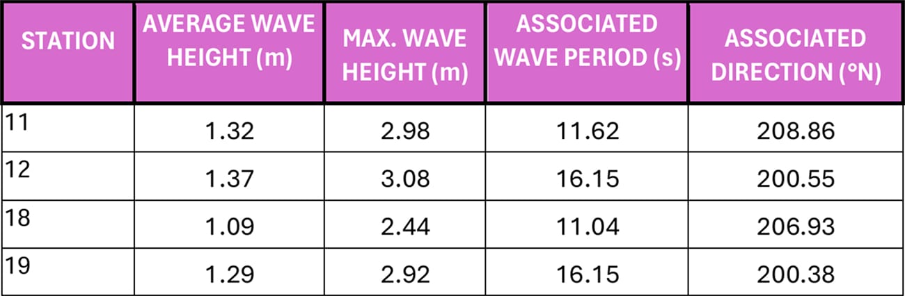
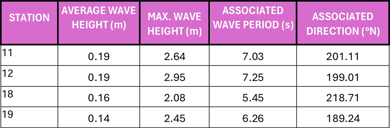
Additional wave statistics are available for all four virtual monitoring stations, as summarized in Table 8-5 to Table 8-7 in the Appendix. These tables detail the average and maximum wave heights, as well as the mean wave periods and directions associated with the largest waves. Given the length of the ERA5 time series, the 50-year return wave heights are expected to be comparable to the maximum values listed in these tables.
Notably, the analysis shows that even the largest seas (swell waves) primarily originate from the southwesterly sector, consistent with the wind patterns depicted in the wave roses (Section 8.5). Since the Burica Peninsula provides effective shelter from waves in this direction, it is more relevant to consider locally generated wind waves from the easterly sector (between north and south), as these waves can approach Puerto Armuelles without obstruction from landmasses or islands.
Wave statistics for the easterly sector, presented in Table 8-7, indicate a mild wave climate offshore of Puerto Armuelles. This further supports the assessment that Puerto Armuelles is a naturally protected location, well-sheltered from significant wave action by Punta Burica, reducing the need for extensive wave protection infrastructure.
Figure 4-4: Wave rose of ERA5 total wave height (m) for the period 1970-2024, Station 19.
Source: Own elaboration
Table 4-3: Statistics of ERA5 Hindcast Wave Data at the Four Selected Stations. Total Wave Energy.
Ocean Currents
Monthly climatology surface ocean current velocities in netCDF file format were sourced from the Copernicus Marine Service’s Global Ocean Reanalysis Product GLOBAL_MULTIYEAR_PHY_001_030. Spanning monthly averages from 1993 – 2016, these climatology field currents help visualize seasonal patterns in coastal ocean currents that could potentially impact operations at Puerto Armuelles.
The Global Ocean Reanalysis Product, similar in nature to the ERA5 reanalysis dataset, is a sophisticated reanalysis tool that reconstructs historical oceanic conditions using advanced numerical models and assimilated observational data. The product represents an eddy-resolving global ocean simulation, capturing mesoscale phenomena with a spatial resolution of 1/12 degrees (~8 kilometers) and 50 standard vertical levels.
To represent monthly seasonal average and maximum surface ocean currents, four seasonal periods were defined, roughly following the Northern hemisphere seasons:
- Spring = April, May, June (AMJ)
- Summer = July, August, September (JAS)
- Fall = October, November, December (OND)
- Winter = January, February, March (JFM)
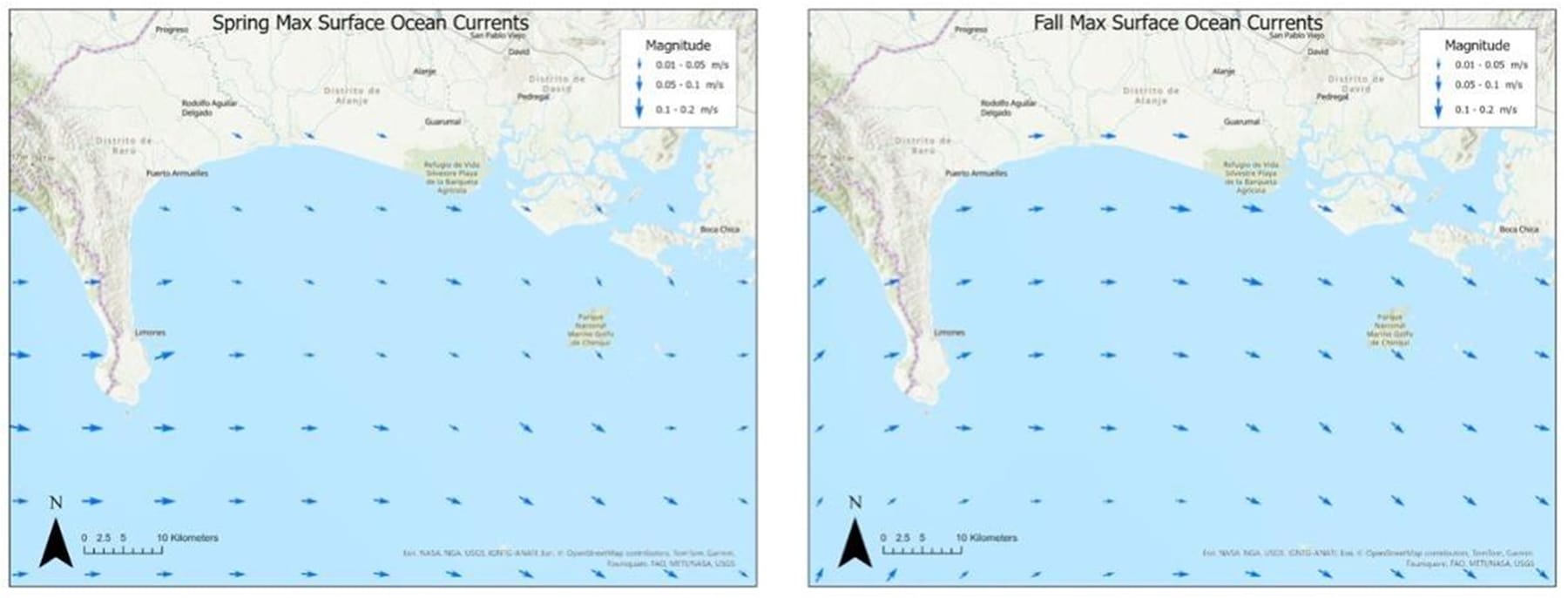
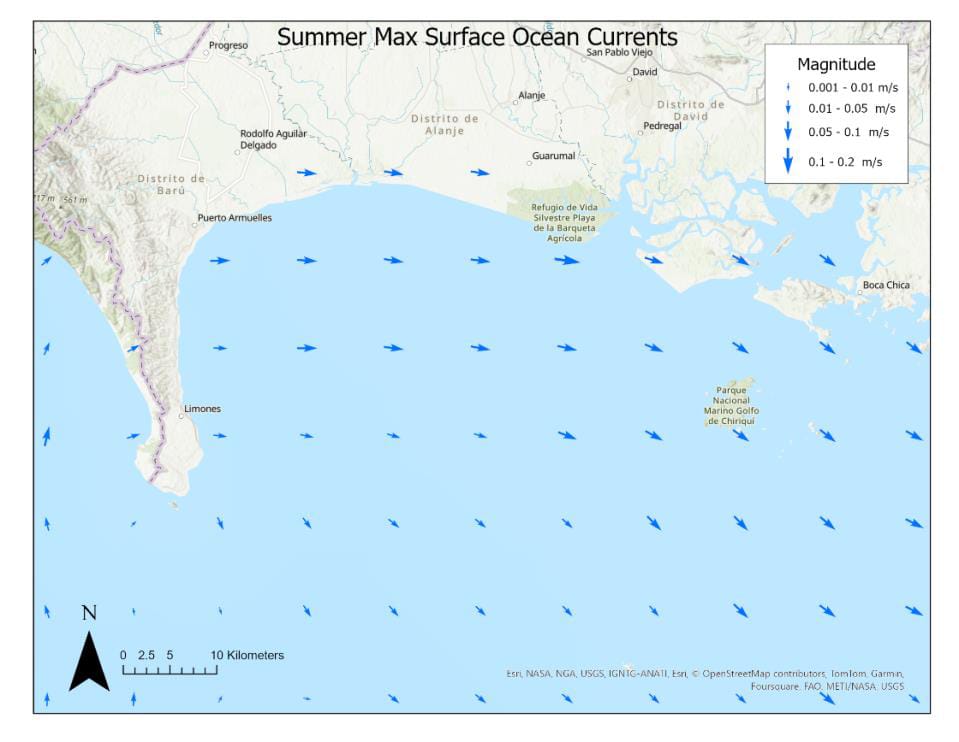
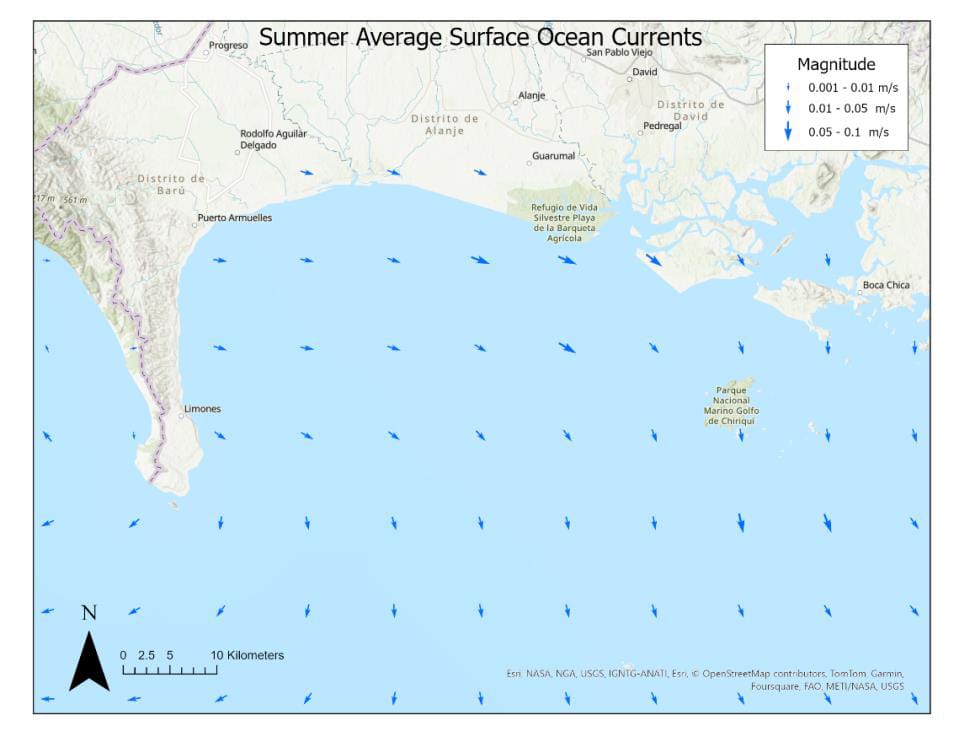
Using the vertical and horizontal velocity components of monthly mean climatology ocean currents at the surface (roughly a -0.4m depth below sea level), the seasonal average and maximums were calculated, and their velocity fields are depicted in the following Figure 4-5 (Spring and Fall) and in Figure 8-9 through Figure 8-14 of Section 8.7 of the Appendix. Surface currents were selected because they are usually strongest and could therefore be most challenging for port operations.
Vector arrows with a larger magnitude depict greater velocities. Typically, the maximum velocities do not exceed 0.2 m/s. The Fall and Summer seasons experience easterly surface currents (from the West), southeasterly in the Spring (from the NW), and southwesterly currents (from the NE) in the Winter, meaning that Puerto Armuelles is sheltered from the action of ocean currents most of the year.
Figure 4-5: Spring (AMJ; left) and Fall (OND; right) Maximum Surface Ocean Currents near Puerto Armuelles.
Source: Own elaboration
4.2 Oceanographic Summary and Conclusions
Puerto Armuelles presents a favorable location for a port siting due to the natural protection of the Burica Peninsula from prevailing south-southwest (SSW) and southwest (SW) swell waves and westerly (W) winds. Locally generated wind waves from easterly directions are small and infrequent, likely reducing the need for extensive breakwater infrastructure and minimizing berth agitation.
Additionally, seasonal ocean currents are weak (typically not exceeding 0.2 m/s) and shift direction throughout the year; they do not appear to present any operational risks. Combined with naturally deep waters and a smaller tidal range than Puerto Barú, Puerto Armuelles significantly reduces the need for costly dredging and lowers potential environmental impacts, particularly to mangrove forests and other sensitive ecosystems, making it an ideal site for port development while allowing for future growth and expansion.
5.0 SUITABLE MATERIALS AND EQUIPMENT AVAILABLE FOR CONSTRUCTION
At this preliminary stage, it is estimated that the storage and cargo handling areas required for Puerto Armuelles would be like those projected for Puerto Barú, adjusted according to the specific site needs. For example, the storage area (Figure 8-2) would be located next to the field offices, installed in 40-foot containers. Materials would be stored in steel warehouses with zinc roofing, while machinery would have a parking area with a stone base.
The equipment and machinery required for the four-year project would be kept in a 10,000 square meter (m²) yard with maintenance workshops, roofed metal structures, perimeter fencing, and security measures. The materials depot, covering an area of 7,500 m², would have specific facilities for different supplies, inventory control personnel, and night security to prevent theft and unauthorized access. Table 5-1 and Table 8-1 through Table 8-3 in Section 8.2 of the Appendix detail the material quantities for the main structures that make up the port. These quantities are still considered preliminary at this stage and would be adjusted according to the proposed location. It is assumed that the materials would be available from the same sources that would provide the materials for the Puerto Barú construction.
The structures proposed in the conceptual design are specified based on the estimated square meters of construction for each section of the Project.
Table 5-1: Construction of Structures
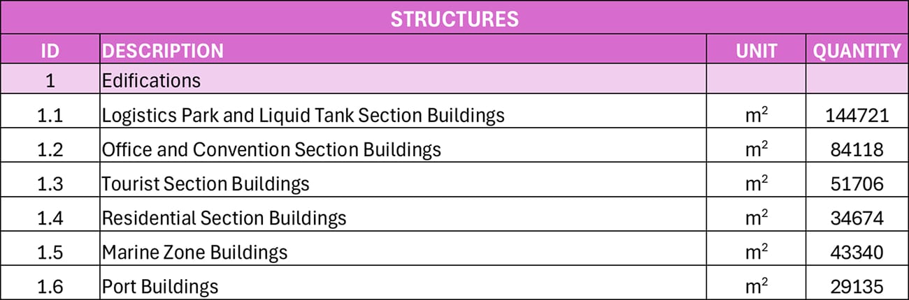
Source: EIA Puerto Barú
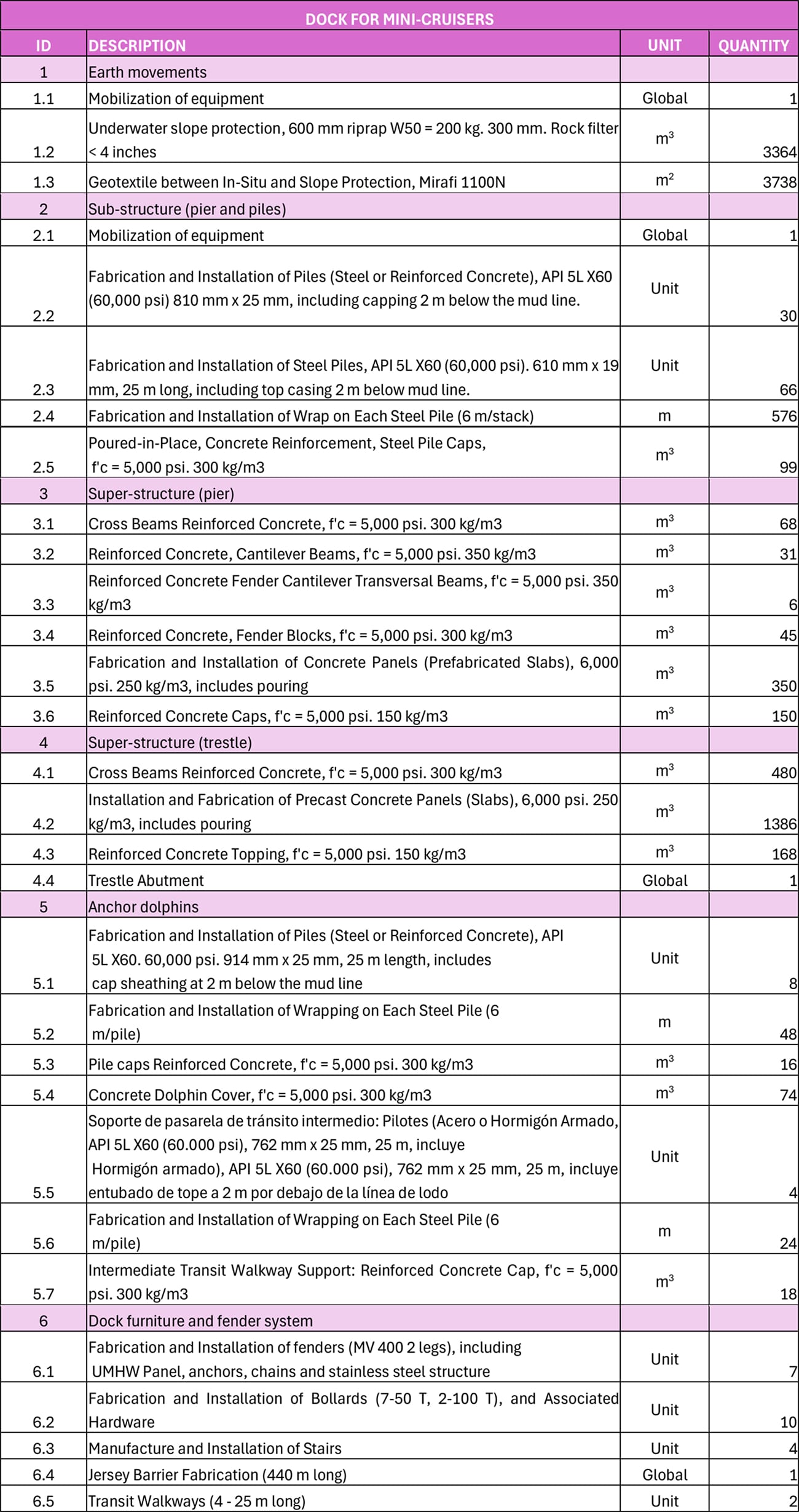
According to the proposed pier design, the quantities of construction materials are detailed in Table 8-1 of the Appendix, divided between the main pier and the mini-cruise pier, which represent the construction effort. The necessary equipment for the project development is also detailed in Table 8-3 of the Appendix. These quantities are still considered preliminary at this stage and would be adjusted according to the construction needs at Puerto Armuelles. However, the availability of equipment in Panama for the project execution was confirmed by Envis contact equipment suppliers in Panama.
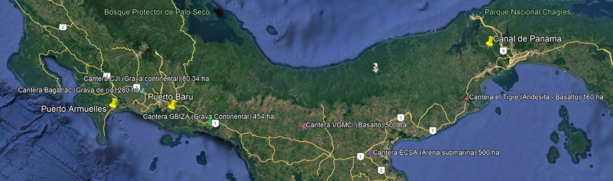
The construction of the port in Puerto Armuelles requires strategic planning to ensure an adequate supply of quality materials that meet the project's technical requirements. In this context, several borrow sources have been identified in Panama, as shown in Figure 5-1. These sources would be crucial for the port's development, particularly for filling activities and the execution of structural and coastal protection works.
Figure 5-1: Identified Borrow Sources
Source: Own elaboration
Based on the information presented above and according to the 2024 report (Ministerio de Comercio e Industrias, 2024), the borrow sources are currently under evaluation or eligibility review. Additionally, the following borrow sources are detailed:
a. Canteras of Grava Continenta
- Cantera GBIZA (454 ha) y Cantera CJ (80.34 ha): These sources provide continental gravel, ideal for structural fills due to its high strength and stability, ensuring a solid base for fill areas and substructures.
b. Canteras of Andesita-Basalto:
- Cantera El Tigre (160 ha) y Cantera VGMC (500 ha): Andesite and basalt are highly dense and durable materials, ideal for constructing coastal protection works such as breakwaters and jetties, as well as underwater foundations.
c. Submarine Sand and River Gravel:
- Cantera ECSA (500 ha): Submarine sand is essential for leveling and concrete mixes. When combined with river gravel, it ensures the stability and quality of concrete structures.
It is recommended to conduct detailed characterization studies of the materials available at each quarry to confirm their technical suitability and ensure compliance with the required quality standards for construction. Additionally, it would be necessary to manage environmental and operational permits for the extraction and transportation of these materials.
6.0 CONCLUSION
Based on this preliminary assessment, Puerto Armuelles presents a viable alternative to Puerto Barú for port development in the Chiriquí region of Panama’s Pacific coast. Its naturally deep waters significantly reduce or eliminate the need for costly dredging while minimizing potential environmental impacts on sensitive ecosystems such as the David mangroves.
A review of ECMWF ERA5 reanalysis data suggests that Charco Azul bay, sheltered by the Burica Peninsula to the west, is characterized by moderate and consistent wind patterns, primarily from the west, with moderate wave activity and weak to moderate ocean currents. These optimal port operating conditions are further demonstrated by the successful operation of Puerto Charco Azul, the Pacific terminal of the Trans-Panama Pipeline.
Additionally, Puerto Armuelles offers scalable infrastructure potential, reliable access to the Pan-American Highway, and adequate proximity to construction materials and equipment. These combined advantages make Puerto Armuelles a practical location for the development of a multipurpose port that aligns with both economic and environmental sustainability goals of the region.
7.0 REFERENCE AND REVIEW DOCUMENTATION
This chapter presents a compilation of references, regulations, technical reports, and studies used as the basis for the development of this project. Below is a detailed list of the reviewed documents and references:
Table 7-1: List of References Provided by Lynker
Source: Own elaboration
Caldwell, P. C., M. A. Merrifield, P. R. Thompson (2015). Sea level measured by tide gauges from global oceans – the Joint Archive for Sea Level holdings (NCEI Accession 0019568), Version 5.5, NOAA National Centers for Environmental Information, Dataset doi: 10.7289/V5V40S7W.
Copernicus Programme. (2023). ERA5 hourly data on single levels from 1940 to present. Climate Data Store. (doi: 10.24381/cds.adbb2d47)
Copernicus Programme. (2023). Global Ocean Physics Reanalysis: The cmems_mod_glo_phy_my_0.083deg climatology_P1M-m Product. EU Copernicus Marine Service. (Downloaded from https://data.marine.copernicus.eu/product/GLOBAL_MULTIYEAR_PHY_001_030/files?path=GLOBAL_MULTIYEAR_PHY_001_030%2Fcmems_mod_glo_phy_my_0.083deg-climatology_P1M-m_202311%2F)
Consultora Ambiental Planeta (2023): Environmental Impact Study Category III for the Project Titled: Puerto Barú Project. Prepared for Ocean Pacific Financial Services, Corp.
GEBCO Compilation Group (2024). GEBCO 2024 Grid (doi:10.5285/1c44ce99-0a0d-5f4f-e063-7086abc0ea0f)
Ministry of Commerce and Industries. (2024). List of non-metallic mineral applications – July 2024. National Directorate of Mineral Resources. https://mici.gob.pa/wp-content/uploads/2024/08/LISTADO-DE-SOLICITUDES-NO-METALICAS-JULIO-2024.pdf
Oceans, General Bathymetric Chart of the. “Gridded Bathymetry Data (General Bathymetric Chart of the Oceans).” GEBCO. Accessed December 2024. https://www.gebco.net/data_and_products/gridded_bathymetry_data/.
Haigh, I.D., M. Marcos, S.A. Talke, P.L. Woodworth, J.R. Hunter, B.S. Hague, A. Arns, E. Bradshaw and P. Thompson (2023): GESLA Version 3: A major update to the global higher-frequency sea-level dataset. Geoscience Data Journal, Volume 10, Issue 3, July 2023. (doi: Part 1, 10.5285/d21a496a-a48e-1f21-e053-6c86abc08512; Part 2, 10.5285/d21a496a-a48f-1f21-e053-6c86abc08512)
Hersbach, H., Bell, B., Berrisford, P., Biavati, G., Horányi, A., Muñoz Sabater, J., Nicolas, J., Peubey, C., Radu, R., Rozum, I., Schepers, D., Simmons, A., Soci, C., Dee, D., Thépaut, J-N. (2023): ERA5 hourly data on single levels from 1940 to present. Copernicus Climate Change Service (C3S) Climate Data Store (CDS), doi: 10.24381/cds.adbb2d47 (Accessed on 15-Dec-2024).
Woodworth, P.L., J.R. Hunter, M. Marcos, P. Caldwell, M. Menéndez, I.D. Haigh (2016); Towards a global higher frequency sea level dataset. Geoscience Data Journal, Volume 3, Issue 2, November 2016. (doi: 10.5285/3b602f74-8374-1e90-e053-6c86abc08d39)
8.0 APPENDIX
8.1 Puerto Barú Conceptual Drawings
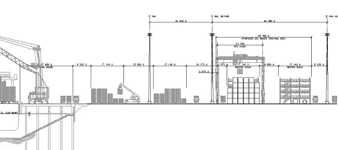
Figure 8-1: Section View – Main Pier
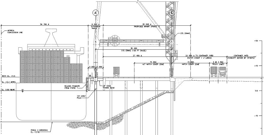
Source: EIA Puerto Barú
Figure 8-2: Container Yard and General Port Section
Source: EIA Puerto Barú
8.2 Sources for Construction Materials
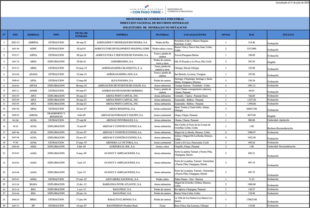
Figure 8-3: Panama Ministry of Trade and Industries National Directorate of Mineral Resources Requests for Non-Metallic Minerals (first page only)
8.3 Construction Materials Tables
Table 8-1: Construction Materials – Main Pier
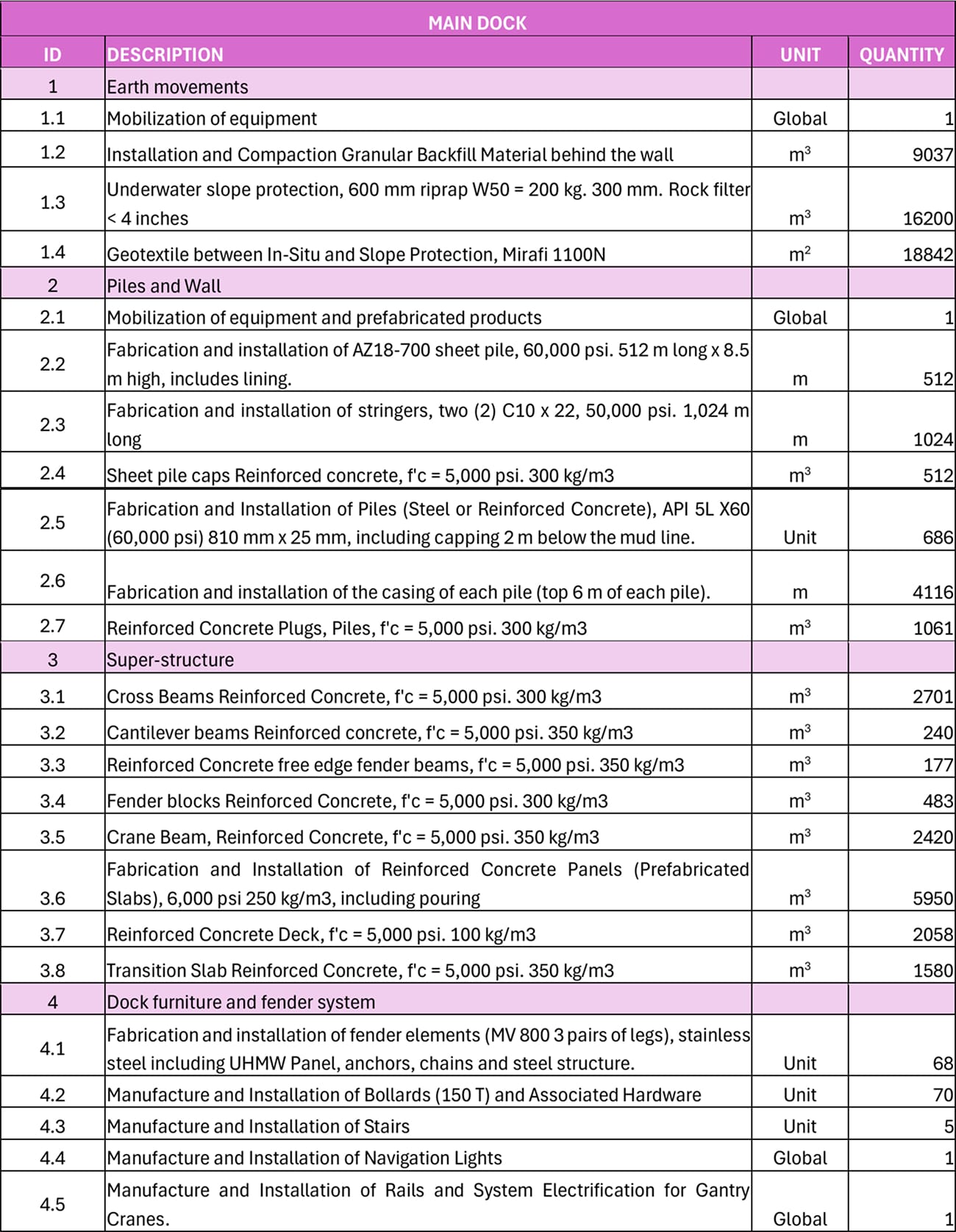
Source: EIA Puerto Barú
Table 8-2: Construction Materials – Mini-Cruise Pier
Source: EIA Puerto Barú
Table 8-3: Equipment by Work Activity
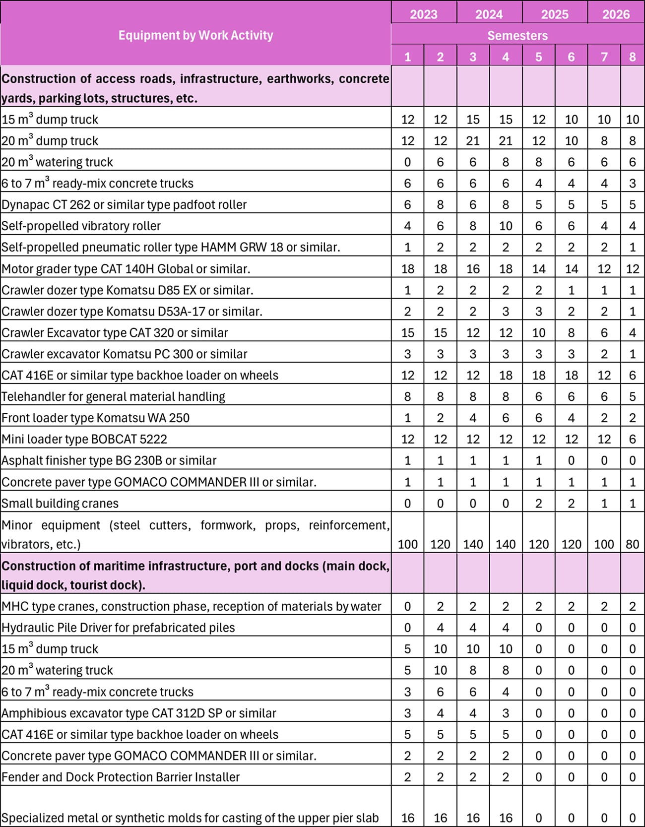
Source: EIA Puerto Barú
8.4 Water Levels
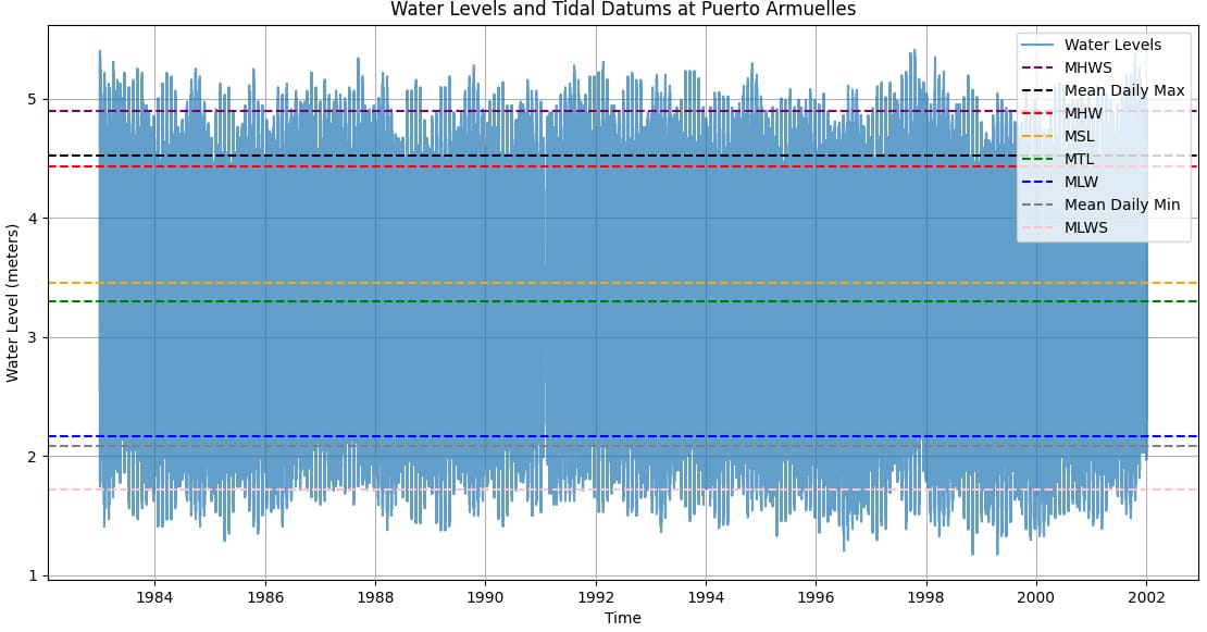
The water levels at Puerto Armuelles were analyzed to determine the extent of tidal shift at the alterative port location and compare them to the conditions at Puerto Barú. Version 3.0 of the Global Extreme Sea Level Analysis (GESLA) dataset, released in November 2021, was downloaded from https://gesla787883612.wordpress.com/downloads/ and used for the analysis presented subsequently. The Joint Archive for Sea Level (JASL)/ University of Hawaii Sea Level Center (UHSLC) dataset plays a central role in GESLA-3 (and earlier versions), see Caldwell et al. (2015) for more details. For additional information about the GESLA-3 dataset, please see the papers by Haigh et al. (2021) and Woodworth et al. (2017). Hourly water level data at Puerto Armuelles was analyzed from 1983 to 2001 using the GESLA3 database (Figure 8-4).
Figure 8-4: Time Series of Hourly Water Levels in meters at Puerto Armuelles for the Period 1983- 2001. Source: GESLA –3 Database. Tidal Datums are Shown as Horizontal Lines.
Source: Own elaboration
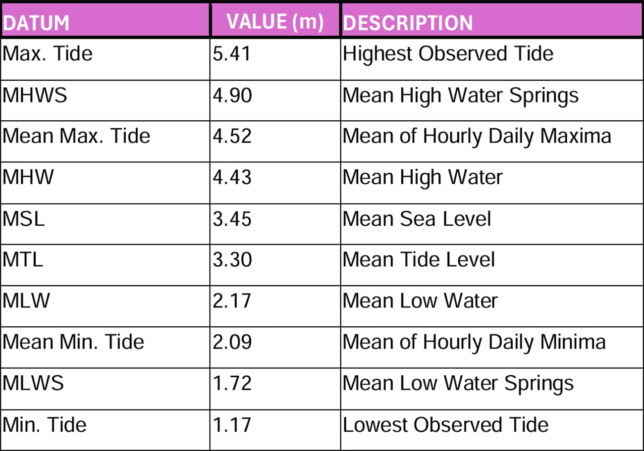
The hourly water level time series for Puerto Armuelles, presented in Figure 8-4, was used to calculate tidal datums, which were subsequently applied to adjust the Mean Sea Level (MSL) to Mean Low Water Springs (MLWS) correction for the GEBCO bathymetry. The calculated tidal datums for Puerto Armuelles are summarized in Table 8-4.
Mean Sea Level (MSL) represents the average sea surface height across all tidal stages over the tidal epoch (1983–2001). Mean High Water Springs (MHWS) is the average height of two consecutive high tides during the spring tide period, when tidal ranges are at their greatest. Mean High Water (MHW) reflects the average of all observed high tides throughout the tidal epoch, while Mean Low Water (MLW) is the average of all recorded low tides during the same period. Mean Tide Level (MTL) is calculated as the arithmetic mean of MHW and MLW. Mean Low Water Springs (MLWS) represents the average height of two consecutive low tides during the spring tide season, coinciding with the greatest tidal range. These tidal datums provide critical reference points for accurately converting bathymetric data to support engineering assessments and port design considerations.
Based on the information in Table 8-4, the MSL to MLWS additive correction to be applied to all bed elevations in the GEBCO bathymetry shown in Figure 4-1 equals (3.45 - 1.72) m = 1.73 m.
Table 8-4: Tidal Datums for Puerto Armuelles
Source: Own elaboration
8.5 ERA5 Wave Reanalysis
Table 8-5: Statistics of ERA5 Hindcast Wave Data at the Four Selected Stations. Swell Waves.
Source: Own elaboration
Table 8-6: Statistics of ERA5 Hindcast Wave Data at the Four Selected Stations. Seas Waves.
Source: Own elaboration
Table 8-7: Statistics of ERA5 Hindcast Wave Data at the Four Selected Stations. Seas Waves from Easterly Quadrant.
Source: Own elaboration
Figure 8-5: Wave roses of ERA5 total wave height for the period 1970-2024. (Top left: Station 19. Top right: Station 18. Bottom left: Station 12. Bottom right: Station 11.)
Source: Own elaboration
Figure 8-6: Wave roses of ERA5 swell wave height for the period 1970-2024. (Top left: Station 19. Top right: Station 18. Bottom left: Station 12. Bottom right: Station 11.)
Source: Own elaboration
Figure 8-7: Wave roses of ERA5 wind wave height for the period 1970-2024. Top left: Station 19. Top right: Station 18. Bottom left: Station 12. Bottom right: Station 11.
Source: Own elaboration
8.6 ERA5 Wind Reanalysis
Figure 8-8: Wind Roses for Four Representative Stations. (Top left: Station 19. Top right: Station 18. Bottom left: Station 12. Bottom right: Station 11.)
Source: Own elaboration
8.7 Ocean Currents
Figure 8-9: Summer (JAS) Maximum Surface Ocean Currents near Puerto Armuelles.
Source: Own elaboration
Figure 8-10: Winter (JFM) Maximum Surface Ocean Currents near Puerto Armuelles

Source: Own elaboration
Figure 8-11: Spring (AMJ) Average Surface Ocean Currents near Puerto Armuelles.

Source: Own elaboration
Figure 8-12: Summer (JAS) Average Surface Ocean Currents near Puerto Armuelles.
Source: Own elaboration
Figure 8-13: Fall (OND) Average Surface Ocean Currents near Puerto Armuelles.
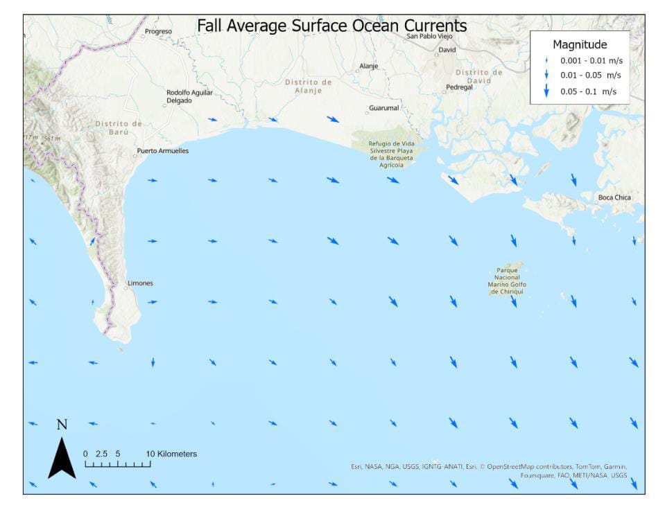
Source: Own elaboration
Figure 8-14: Winter (JFM) Average Surface Ocean Currents near Puerto Armuelles.

Source: Own elaboration